
ABOUT MAŽEIKIAI
Facts about Mažeikiai district
Short history about Mažeikiai
Mažeikiai was first mentioned in written sources in 1335. The town started growing in 1869 when the Libau–Romny Railway connecting Vilnius and Liepaja was constructed, but it begun to thrive when it was decided to place several big plants in 1960. Mažeikiai witnessed rapid growth when it was selected as the home location of the first oil refinery (ORLEN Lietuva oil refinery plant) in the Baltic states, which began operations in 1980 about 12 miles (20 km) northwest of the town.
Geographic location
The Mažeikiai district is located in north-western Lithuania along the Venta river, on the periphery of two Baltic peoples, the Lithuanians and the Latvians. In the north, the Mažeikiai district borders with the Republic of Latvia, in the east – with Akmenė district, in the southeast – with Telšiai district, in the southwest – with Plungė district, and in the west – with Skuodas district.
Territory
The area of the district is 1,220.2 km², of which 32 km² is occupied by cities, towns, and settlements, 22 km² is occupied by industrial companies and roads, 614 km² is used for agriculture, 273 km² consists of forest land, and 68 km² are used for various other purposes. The district stretches 43.5 km from west to east, and 38 km from north to south. The current boundaries of the Mažeikiai district were set in 2,000.
Residents
Mažeikiai district is one of the most densely populated districts, there are 59 persons per square km (in Lithuania as a whole – 50). Since the beginning of 2020 about 52,000 people live in the district, of whom 32,500 in Mažeikiai city, and 19,500 in villages and the countryside.
Transportation
Important railway lines cross the district: Liepoja (Latvia) – Šiauliai – Kaunas – Vilnius and Riga (Latvia) – Mažeikiai – Klaipėda. The distance from Mažeikiai to the port of Klaipėda is only 110 km, and the distance from Mažeikiai to the port and airport of Riga is 150 km. The nearest passenger railway stations are in Telšiai and Plungė. The distance from Mažeikiai to the nearest trunk road (the A12 highway), which passes through the city of Šiauliai, is 100 km.
Business
The image of business in the Mažeikiai district has been formed to a great extent by the oil refinery and oil-processing company, AB “Orlen Lietuva” (formerly, AB “Mažeikių nafta”). However, the area is not just related to the oil business. There are many highly-qualified specialists and workers, and for this reason the district has a large reserve of intellectual capital. Besides the oil refinery there are at least three other important industry sectors – machinery building & metalworking, food processing, wood processing & furniture production and many other modern companies from other sectors.
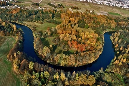
Landscape
The Mažeikiai district is located in three geographic districts. The Mažeikiai district’s central, northern, eastern, and south-eastern parts are in the plain of the Venta’s mid-river. The western and northern parts of the district are on the edge of the Western Curonian heights. The southern and southwestern parts of the district are on the edge of the Eastern Samogitian plateau. Plains are characteristics of the land scape of the district.
The forested area of the Mažeikiai district is 27.1%, that is, less than the average in Lithuania.
Detailed information about Mažeikiai district can be found here.


